|
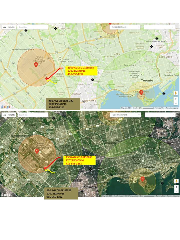
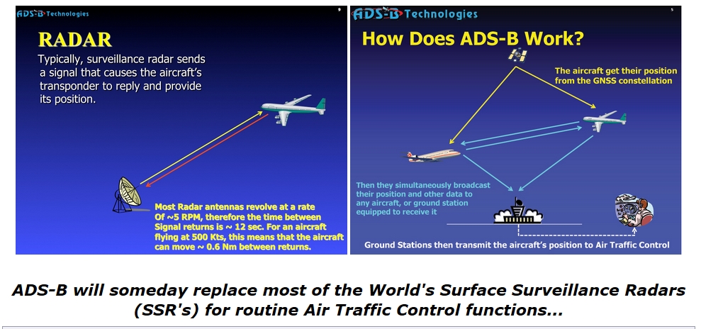
Registration is a starting point. It's a simple easy process that FAA has already begun processing for several months now and it's going to be effective once the rules are established. Everyone already "registers" the dji series drones when they do on-line set-up of a new bird . . and tie their email address to the model serial number for maintenance and software upgrades. That should also immediately offer you registration with the country or countries of your choice. . . like (TCCA) Transport Canada Civil Aviation and/or USA (FAA). You should be allowed to opt out and refuse this, but that should then limit your altitude to 300 or 400ft depending on your launch location along with the other existing restricted zones. Go fly wherever you want outside of controlled airspace and below 300ft AGL. That allows anyone quite a bit of latitude if you are a recreational flyer ( notice I did not say "pilot"). Recreational flyers are not really "pilots" because they are not trained for flight within civil airspace. Maybe you just want to have an aerial view, take some photos or maybe do small business tasks like weddings or real estate etc. If you need to do more complex flying commercially, I'll explain that later. For now, how would that work and not be a burden on authorities? Here's how. "Drone Air Traffic Control" does not have to be a burden for Air Traffic Control (ATC) or commercial drone operators in order to allow complete conformance with current civil aviation airspace (Canada and US) . . and at the same time weed out the reckless ones . . . This needs to be discussed with manufacturers as well as the government side of this equation to see what collaboration is needed of course . . and then there's the budget . . There needs to be budgets. There are always budgets . . but my analysis of this is it's fairly cheap to do and technically quite simple. I think I could set up a simple trial "proof of concept" with just a little coo-operation from both sides. Here are a 3 scenarios: 1. You just bought a new UAV and have little if any flying experience or aviation knowledge. You register your machine with the manufacturer (just as you do today), but decline registration with TCCA or the FAA. When you fly the normal B3YFly boundaries still prevent you from inadvertently entering protected airspace and your flights are capped at 300-400ft depending on jurisdiction . . (SET MAX ALTITUDE is greyed out). If you try and go higher the machine inhibits flight above the 300 or 400ft and prompts you as it does now with an audio warning but adds a dialog box that says. "WARNING you are not registered to fly above xxx hundred feet above ground. Please register with TCCA or the FAA." This is done only over a web page, not "in-flight". 2. If you are registered with TCAA or FAA and flying recreationally or as a small business, then you probably have a commercial UAV authorization like SFOC in Canada or FAA Part 107 in the US. There already is a setting in the controller interface that allows you to override altitude and airspace restrictions. In dji equipment it's called UNLIMIT. Instead of entering a height limit like you do now attempts to go above 300ft would then bring up a dialog if you have not already acknowledged that in your start up menus. If not, then using the dji example under "General Settings" click "Unlimit" and a dialog is presented that says, "Enter your SFOC/FAA approval code". This is given to you with approval authorization by TCCA or FAA. Enter the code and you are free to go. . . because you accept responsibility for flying safely, like any other "pilot" who knows the rules. . . and you are likely already working under a filed NOTAM and in communications with ATC if necessary . . but here's the KEY. When you do enter a valid code then when flying above 300ft or entering a prohibited zone, the machine will only do so if there is a valid wifi or cellular link from your controller to a TCAA or FAA website. As it is now, you have to connect to a dji server anyway to "UNLIMIT" your machine. But a new feature of the interface would be to limit to 300ft in Canada and 400ft in USA in ALL Cases. This additional website link accepts your authorization code. From then on, during the flight (in the background) the machine reports as small packet every 10 seconds (6 times a minute) < TIME, UAV ID, LAT , LONG, ALTITUDE>. This data is fed in real time to a map display that can then be read in near real-time (few seconds delay) for ATC controllers to monitor and warn you or civilian air traffic. This info is also relayed to ADS-B (the Automatic Dependent Surveillance - Broadcast system (see below) at the same time and available to commercial air traffic. (see ADS-B Diagram). If ATC knows about you and you are following the rules no further clearance is required. If there is a potential conflict or if you violate the rules of the airspace then an ATC person can call your cell wherever you are and ask you to stop or modify your activities . . . and if you ignore the call or you can't be contacted to avoid an incident, then at least they know who to call and where to send the authorities to take away your privileges or throw you in jail if you are THAT irresponsible you cannot be trusted. . 3. For commercial operators, if you are planning flying near or in a restricted zone and have been authorized with an email, you have filed a NOTAM, you've been in touch with ATC or tower on the appropriate frequency then everyone is communicating and there are no surprises. As a drone pilot all you have to do is acknowledge you know the rules. No more hanging around final at 1000ft or seeing how high you can go without advertising your recklessness. Manufacturers who do not offer this simple software inhibit should not be allowed to sell these models within the jurisdiction and a whole bunch more regulations are not required. Basically, dji and other machines (and many other small ones under 25kg) have their email associated with there model serial number stored on a server somewhere to track maintenance, software upgrades and the like. That's certainly the case with Phantom and Mavic Pro I know. In order to "Un-limit" Fly-Safe zones you send the request over wifi to have the system verify your authorization to do so. There is a simple map display website interface needed for ATC to notice errant drone behaviour and we can all get along . . and there will be fewer new rules needed and safer skies for everyone. I admit there is lots more work and collaboration required to make this all a reality but the technology is already in place in the drone industry and ATC just needs the funding to implement a reliable back-end to a secure website and manufacturers need to be encouraged ( or legislated like any aircraft manufacturer) to add a small layer of protection to their already very comprehensive controller interfaces. "Let's TALK about it!" Concept - ATC Web Based Drone Monitoring Display CURRENT AUTOMATIC DEPENDENT SURVEILLANCE - BROADCAST SYSTEM
2 Comments
9/15/2022 08:06:36 am
Thanks for your interest. This post is a bit dated (before the rules) but something a LOT simpler could be implemented except for the fact that there are now RULES that make everything overly complicated. If you have more comments you can direct them to me at [email protected]. Thanks
Reply
Leave a Reply. |
AuthorEx RCAF Flight Cmdr, Combat Flying Instructor and Flight Safety Officer, 25+yrs flying experience, Military and corporate flying in Canada US and NATO. Drone builder and pilot since 2014. Archives
November 2016
Categories |
HoursM-F: 7am - 9pm
wknds noon - 5pm |
Telephone416-523-5230
|
|


 RSS Feed